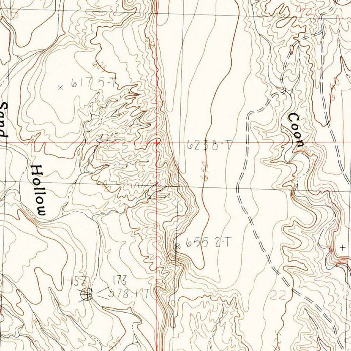
Map of Mesquite, Nevada by USGS, 1985 – Virgin River Valley & Lincoln County
Map of Mesquite, Nevada by USGS, 1985 – Virgin River Valley & Lincoln County
✅ Made In USA
✅ Quick Delivery
✅ Cruelty Free
BUNDLE & SAVE
BUNDLE & SAVE
Couldn't load pickup availability
-
Ordered
- - -
Order Ready
- - -
Delivered

Map of Mesquite, Nevada by USGS, 1985 – Virgin River Valley & Lincoln County
The original title, “Mesquite Quadrangle,” identifies a focused 1:24,000 topographic portrait of Mesquite, Nevada, published by the United States Geological Survey in 1985 with a 1985 imprint. Marked as provisional, the map belongs to the USGS tradition of precise, field-oriented quadrangle mapping, where every contour, wash, road, and settlement feature is organized for close reading of the land. Mesquite appears not as an isolated town, but as part of a larger desert valley system shaped by elevation, drainage, and movement through rugged terrain. The Virgin River and its associated lowlands provide the geographic anchor, while surrounding slopes and uplands are rendered through the disciplined language of contour lines.
The United States Geological Survey brought more than a century of scientific authority to maps of this kind. Established in 1879, the agency became the nation’s principal interpreter of geology, water, terrain, and natural resources, and its topographic quadrangles are among the most influential cartographic works produced in the United States. The “Mesquite Quadrangle” reflects that institutional clarity: it is not decorative in the conventional sense, but elegant through precision. Its systematic symbols, measured contours, and careful hierarchy of roads, waterways, and built features create a visual grammar that is immediately legible. For collectors, such maps embody the intersection of science, landscape, and national infrastructure.
Mesquite occupies a distinctive position in the Virgin River valley, close to the meeting ground of Nevada, Arizona, and Utah, where desert basins and upland margins define the regional character. The map captures the settlement and its environs before later decades of expansion transformed Mesquite into a larger resort and retirement community. Roads and pathways trace the practical patterns of movement across the valley floor, while contour intervals reveal the transition from habitable lowland to higher, more broken terrain. The Virgin River, one of the defining waterways of the region, serves as both a geographic corridor and an ecological presence in an otherwise arid landscape.
The topographic style gives particular force to the ruggedness surrounding Mesquite. Contour lines gather and spread across the sheet, translating relief into a finely calibrated visual rhythm: tight curves suggest steeper rises, while broader spacing marks gentler valley floors and open desert surfaces. Such mapping allows the viewer to perceive not only where places are, but how the land behaves. Drainages, washes, possible intermittent watercourses, and valley margins are all part of the map’s story. In a desert setting, these details matter profoundly, revealing how water, erosion, and elevation govern settlement, travel, and the distribution of natural features across the landscape.
As a 1985 document, the “Mesquite Quadrangle” also preserves a valuable moment in the recent history of southern Nevada. Since its publication, the Mesquite area has seen notable changes in land use, transportation patterns, and urban development, making the map a record of a landscape on the cusp of transformation. Its provisional status adds a further layer of interest, suggesting a working cartographic product issued to make timely geographic information available. Today, the map invites comparison between the measured terrain of the late twentieth century and the evolving built environment that followed, offering collectors a compelling view of Mesquite before many modern changes reshaped its surroundings.
Cities, towns and places on this map
- Mesquite
- Virgin River
- Valley
- Lincoln County
- Higher terrain and lower valleys
- Surrounding roads and pathways
- Possible parks and wilderness areas
- Geological features and landmarks
Historical context & cartographic details
- Map name: Mesquite Quadrangle
- Published by the United States Geological Survey (USGS)
- Created in 1985 with a 1985 imprint
- Historical 1:24,000 topographical map
- Shows Mesquite, Nevada, and the surrounding area
- Marked as provisional
- Uses a traditional topographic design style
- Features contour lines to indicate elevation changes
- Includes shading and fine detail to depict natural features
- Clear, systematic layout supports navigation and terrain interpretation
- Depicts rugged terrain around Mesquite
- Shows valleys and possible water features such as lakes and rivers
- Serves as a historical record of the area before later urban development, land-use changes, and ecological shifts
Looking for a particular place? Review the detailed images to confirm that the town, landmark or feature you have in mind appears on the map. If you are unsure, ask our workshop to check before you order.
Detailed maps are especially rewarding at larger sizes, where names, boundaries and decorative features have more room to be appreciated. Use the close-up preview and size guide to choose the right scale for your wall.
This map looks amazing at sizes all the way up to 50in (125cm). If you are looking for a larger map, please get in touch.
The model in the listing images is holding the 16x20in (40x50cm) version of this map.
Where personalisation is available, you can add a short title or dedication, mark one meaningful place, or request one considered visual detail. See personalised map examples.
Every piece is printed to museum-grade archival standards using fade-resistant pigment inks on acid-free matte paper. Choose an unframed map print, framed map or canvas using the finish options above. Framed maps use crystal-clear optical acrylic and arrive ready to hang.
With its rich detail and strong sense of place, this map makes a considered gift for a new home, anniversary, retirement or anyone with a personal connection to the area shown. Still deciding? Explore our collection of rare old and vintage maps to discover another place, period or style.
Collapsible row
Collapsible row