Old Map of Albuquerque, New Mexico by USGS, 1934 – Rio Grande River & Grant
Old Map of Albuquerque, New Mexico by USGS, 1934 – Rio Grande River & Grant
✅ Made In USA
✅ Quick Delivery
✅ Cruelty Free
BUNDLE & SAVE
BUNDLE & SAVE
Couldn't load pickup availability
-
Ordered
- - -
Order Ready
- - -
Delivered

Old Map of Albuquerque, New Mexico by USGS, 1934 – Rio Grande River & Grant
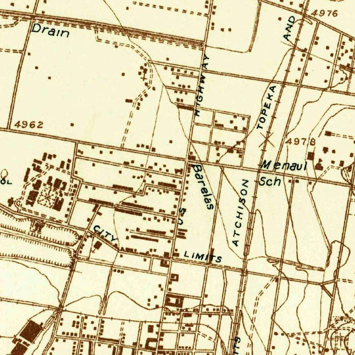
Titled “West Albuquerque,” this 1934 United States Geological Survey map presents Albuquerque, New Mexico, and its western environs at the intimate 1:24,000 scale, where city blocks, roads, trails, river courses, and relief are rendered with exacting clarity. Issued with the special “advance” designation, it captures the landscape in a form associated with early or preliminary topographic publication, giving the map an added documentary interest. The sheet records Albuquerque before the sweeping postwar growth that would transform it into one of the Southwest’s major metropolitan centers. Here, the city appears in closer conversation with the Rio Grande, surrounding agricultural land, and the open terrain beyond—an urban place still visibly shaped by river, elevation, and desert geography.
The United States Geological Survey, founded in 1879, brought a new standard of scientific rigor to American mapping, and this sheet reflects the agency’s disciplined visual language. Rather than ornamental flourish, the map derives its elegance from precision: fine contour lines, carefully differentiated roads and tracks, named settlements, drainage features, and the measured geometry of the urban grid. Typical of USGS topographic work of the period, the restrained palette emphasizes legibility while allowing the terrain itself to command attention. Every line serves a purpose, whether marking elevation, movement, settlement, or water. For collectors, the result is a sophisticated fusion of governmental authority and landscape portraiture, transforming technical survey data into a quietly beautiful historical document.
At the heart of the map lies Albuquerque, shown as a settled urban place whose form was still compact compared with its later twentieth-century expansion. Streets, transportation routes, and developed areas reveal a city rooted in its older patterns of growth, with the surrounding land not yet consumed by suburban sprawl. Nearby Grant and other local features help situate the city within a broader human landscape of roads, trails, cultivated plots, and open ground. The Rio Grande provides the map’s most significant natural axis, its course anchoring settlement and agriculture alike. In this 1934 view, Albuquerque is not merely a city on a map, but a community shaped by water, mobility, and the practical demands of life in the high desert.
The topographic character of the sheet is especially compelling. Contour lines describe the subtle and sometimes dramatic changes in elevation around Albuquerque, giving visual form to hills, slopes, and transitional terrain beyond the urban grid. These contours make clear that the city occupies a landscape of complexity rather than flat abstraction: river valley, cultivated land, rising ground, and arid expanses all meet within the same surveyed frame. Roads and trails thread through this terrain, suggesting both established movement and more provisional routes into the surrounding country. The map’s attention to elevation and drainage offers more than navigational value; it reveals the environmental logic that influenced settlement, agriculture, engineering, and expansion in central New Mexico.
As a historical image of Albuquerque in 1934, “West Albuquerque” offers a rare glimpse of the city before wartime industry, automobile suburbs, and late twentieth-century growth redrew the region’s human geography. It preserves a moment when the relationship between the urban center and its natural setting remained plainly visible: the Rio Grande corridor, agricultural lands, undeveloped margins, and contoured hills all hold their place alongside the city itself. For anyone interested in New Mexico, urban history, or American topographic mapping, the sheet is both evidence and atmosphere. It documents not only where things were, but how Albuquerque sat within its landscape—poised between river and desert, tradition and expansion, measured with the calm authority of the USGS.
Cities, towns and places on this map
- Albuquerque
- Grant
- Rio Grande River
- Various roads and trails
- Surrounding hills and topography
- Urban layout of the city of Albuquerque
- Areas of agricultural land
- Contoured terrain indicating elevation variations
Historical context & cartographic details
- Created in 1934
- Produced by the United States Geological Survey, founded in 1879
- Historical 1:24,000 topographical map of Albuquerque, New Mexico, and the surrounding area
- Issued with special features categorized as “advance”
- Uses detailed contour lines to show elevation changes across the terrain
- Likely employs a muted color palette, mainly in brown tones typical of USGS topographical maps
- Shows Albuquerque before significant post-war expansion and urban development
- Provides insight into how the city and its surrounding landscape have changed over time
Looking for a particular place? Review the detailed images to confirm that the town, landmark or feature you have in mind appears on the map. If you are unsure, ask our workshop to check before you order.
Detailed maps are especially rewarding at larger sizes, where names, boundaries and decorative features have more room to be appreciated. Use the close-up preview and size guide to choose the right scale for your wall.
This map looks amazing at sizes all the way up to 50in (125cm). If you are looking for a larger map, please get in touch.
The model in the listing images is holding the 16x20in (40x50cm) version of this map.
Where personalisation is available, you can add a short title or dedication, mark one meaningful place, or request one considered visual detail. See personalised map examples.
Every piece is printed to museum-grade archival standards using fade-resistant pigment inks on acid-free matte paper. Choose an unframed map print, framed map or canvas using the finish options above. Framed maps use crystal-clear optical acrylic and arrive ready to hang.
With its rich detail and strong sense of place, this map makes a considered gift for a new home, anniversary, retirement or anyone with a personal connection to the area shown. Still deciding? Explore our collection of rare old and vintage maps to discover another place, period or style.
Collapsible row
Collapsible row