Old Map of New Paltz, New York by USGS, 1943 – Clintondale, Shawangunk Ridge & Wallkill River
Old Map of New Paltz, New York by USGS, 1943 – Clintondale, Shawangunk Ridge & Wallkill River
✅ Made In USA
✅ Quick Delivery
✅ Cruelty Free
BUNDLE & SAVE
BUNDLE & SAVE
Couldn't load pickup availability
-
Ordered
- - -
Order Ready
- - -
Delivered

Old Map of New Paltz, New York by USGS, 1943 – Clintondale, Shawangunk Ridge & Wallkill River
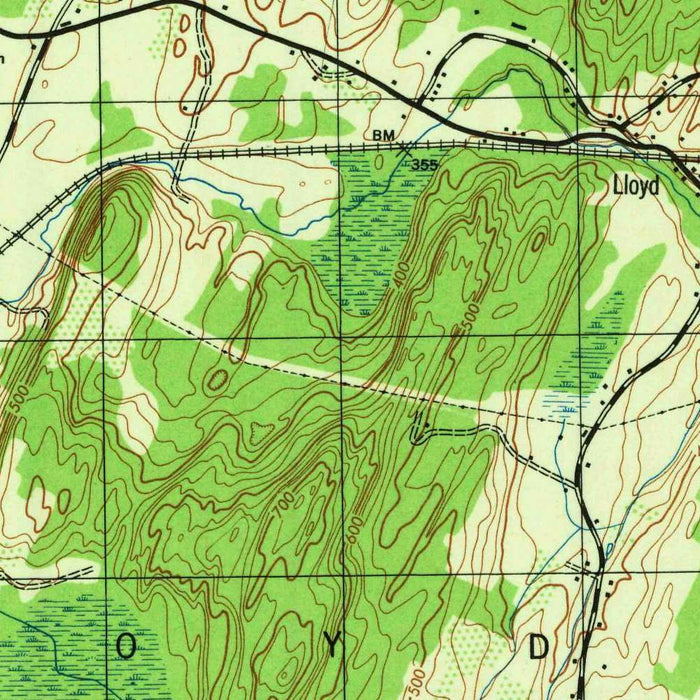
Published in 1943, the US Geological Survey’s “Clintondale” presents a richly detailed topographical portrait of New Paltz and its neighboring Hudson Valley communities at a moment when rural roads, rail lines, farms, and wooded uplands still defined much of the region. Drawn at the highly legible 1:31,680 scale, the map captures Clintondale, Modena, Gardiner, Rosendale, and New Paltz within a carefully measured landscape of contours, waterways, transportation corridors, and settlement patterns. Its green woodland shading and precise elevation lines evoke the classic visual language of mid-twentieth-century USGS cartography: scientific, restrained, and quietly beautiful. More than a geographic document, it is a snapshot of a changing New York landscape before later suburban growth reshaped the approaches to New Paltz and the Wallkill Valley.
The United States Geological Survey had, by 1943, become one of the most important cartographic institutions in the world, producing maps that served engineers, planners, geologists, soldiers, conservationists, and ordinary travelers alike. Founded in 1879, the USGS brought rigorous field survey methods to the vast task of mapping the United States, and its topographic quadrangles became essential tools for understanding terrain. During the Second World War era, such maps had added strategic importance, supporting infrastructure planning, resource study, and national preparedness. “Clintondale” reflects this disciplined tradition: every road, stream, railroad, ridge, and settlement is recorded not for ornament, but for utility. Yet the result has a quiet elegance, where data and design combine into an exceptionally clear vision of place.
New Paltz, one of the principal locations shown, lends the map particular historical resonance. Founded by Huguenot settlers in the late seventeenth century, the village sits amid some of the Hudson Valley’s most storied cultural and natural landscapes. By the 1940s, New Paltz was already known for its colonial heritage, agricultural surroundings, and access to the dramatic country west of town. Nearby Gardiner and Modena appear within a network of local roads and rural parcels, while Clintondale anchors the eastern portion of the mapped area. The Wallkill River, a defining feature of the valley, threads through the region, shaping farmland, settlement, and transportation routes. The map preserves these communities before the stronger imprint of postwar development, highway expansion, and commuter-era transformation.
The Shawangunk Ridge gives the map much of its topographical drama. Rising west of the Wallkill Valley, the ridge forms a striking escarpment of resistant rock, wooded slopes, and high viewpoints that have long attracted climbers, hikers, naturalists, and artists. On the map, its presence is expressed through tightly drawn contour lines that articulate slopes, hollows, and upland forms with scientific precision. The surrounding unnamed hills and valleys are equally important, revealing a landscape shaped by bedrock, glacial history, drainage, and centuries of human use. Green shading marks forested terrain, while open areas suggest cultivated land and settlement. The contrast between valley floor and rugged upland is one of the map’s great pleasures, making the geography of the New Paltz region immediately legible.
Transportation details give “Clintondale” another layer of historical interest. Roads linking New Paltz, Clintondale, Modena, Gardiner, and Rosendale trace the patterns of everyday movement in the mid-twentieth-century Hudson Valley, while railroads hint at earlier and ongoing systems of commerce, quarrying, agricultural shipment, and passenger travel. Rosendale, historically associated with cement production and canal-era industry, connects the map to the broader industrial history of Ulster County. At the same time, the wooded tracts, ridgelines, and river corridors anticipate the region’s later identity as a destination for recreation and conservation. Since 1943, the landscape has changed substantially, with expanded development around New Paltz and shifting environmental priorities. This map preserves the region at a fascinating threshold between rural inheritance and modern transformation.
Cities, towns and places on this map
- New Paltz
- Clintondale
- Modena
- Rosendale
- Gardiner
- Wallkill River
- Shawangunk Ridge
- Various unnamed hills and valleys
- Roadways, notably major routes connecting towns
- Railroads
- Local parks or forested areas
Historical context & cartographic details
- Produced by the US Geological Survey, this historical topographical map is dated 1943.
- The map was created at a scale of 1:31,680.
- The USGS is known for detailed topographical surveys and has played a crucial role in mapping the United States.
- USGS maps provided vital data for land use, research, and military operations.
- The map uses green shading to indicate vegetation.
- Elevation relief is shown through contour lines, a standard stylistic feature of USGS topographical maps.
- The terrain is shown with varied elevations, including hills and valleys typical of the region.
- Since 1943, urban development and environmental change have significantly altered parts of the landscape shown on the map.
Looking for a particular place? Review the detailed images to confirm that the town, landmark or feature you have in mind appears on the map. If you are unsure, ask our workshop to check before you order.
Detailed maps are especially rewarding at larger sizes, where names, boundaries and decorative features have more room to be appreciated. Use the close-up preview and size guide to choose the right scale for your wall.
This map looks amazing at sizes all the way up to 50in (125cm). If you are looking for a larger map, please get in touch.
The model in the listing images is holding the 16x20in (40x50cm) version of this map.
Where personalisation is available, you can add a short title or dedication, mark one meaningful place, or request one considered visual detail. See personalised map examples.
Every piece is printed to museum-grade archival standards using fade-resistant pigment inks on acid-free matte paper. Choose an unframed map print, framed map or canvas using the finish options above. Framed maps use crystal-clear optical acrylic and arrive ready to hang.
With its rich detail and strong sense of place, this map makes a considered gift for a new home, anniversary, retirement or anyone with a personal connection to the area shown. Still deciding? Explore our collection of rare old and vintage maps to discover another place, period or style.
Collapsible row
Collapsible row