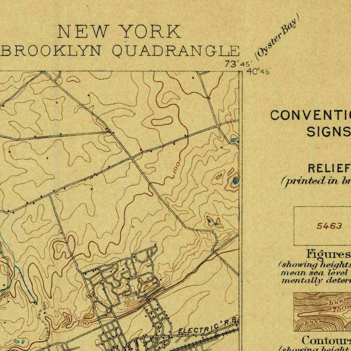
Old Map of SoHo, New York by USGS, 1898 – Brooklyn, Manhattan & East River
Old Map of SoHo, New York by USGS, 1898 – Brooklyn, Manhattan & East River
✅ Made In USA
✅ Quick Delivery
✅ Cruelty Free
BUNDLE & SAVE
BUNDLE & SAVE
Couldn't load pickup availability
-
Ordered
- - -
Order Ready
- - -
Delivered

Old Map of SoHo, New York by USGS, 1898 – Brooklyn, Manhattan & East River
Published in 1898, the US Geological Survey’s “Topographic Sheet, Brooklyn” presents New York at a pivotal moment, when Brooklyn had recently entered the era of Greater New York and its nineteenth-century landscape was being rapidly absorbed into the modern metropolis. At a scale of 1:62,500, the map captures an unusually rich balance of urban precision and natural form: the ordered street grids of Brooklyn and Manhattan, the watery margins of the East River and Upper New York Bay, and the low-lying coastal geography stretching toward Jamaica Bay and Rockaway Beach. Soho appears within the broader urban fabric of lower Manhattan, while Brooklyn’s neighborhoods, parks, canals, railways, and avenues reveal a city in transition from independent municipality to essential borough.
The United States Geological Survey, founded in 1879, brought scientific rigor and national consistency to the mapping of American landscapes, and this sheet reflects the agency’s authoritative late nineteenth-century style. Unlike purely commercial city plans, USGS topographic maps were designed to describe the land itself: elevation, drainage, coastlines, roads, railways, settlement, and engineered infrastructure all appear as parts of a single geographic system. Contour lines and subtle shading give shape to a terrain often imagined as flat, while blue water features distinguish the intricate harbor environment that made New York a global port. The result is both practical and deeply evocative—a federal survey of a city whose expansion depended on the precise negotiation of land, water, and transportation.
Brooklyn dominates the composition, and the map is especially revealing in its depiction of a borough still carrying traces of its earlier rural and suburban character. Prospect Park, completed only decades before, appears as a major planned landscape amid the accelerating grid of streets and avenues. The Gowanus Canal, an industrial artery cut into the wetlands of South Brooklyn, signals the importance of manufacturing, shipping, and urban engineering in the district’s growth. Railway and transit lines trace the new mobility that connected residential neighborhoods with waterfront jobs, ferries, and Manhattan commerce. In these details, the map records Brooklyn not simply as a place of streets, but as an evolving organism shaped by parks, industry, infrastructure, and immigration.
The surrounding waterways are among the map’s most compelling features. The East River, Newtown Creek, Upper New York Bay, Jamaica Bay, and the approaches to Rockaway Beach define the region as an archipelago of commerce and recreation, where tidal channels, marshes, docks, and ferries were as important as roads. Newtown Creek marks the industrial boundary between Brooklyn and Queens, while Jamaica Bay and Rockaway point toward a different landscape of sand, marsh, and seaside leisure. These blue-limned features show how water governed the city’s possibilities: it carried goods, divided jurisdictions, framed neighborhoods, and invited ambitious schemes of reclamation, bridge-building, harbor improvement, and suburban development.
As a historical document, “Topographic Sheet, Brooklyn” captures New York just before the great transformations of the twentieth century: subway expansion, bridge construction, waterfront redevelopment, and the densification of outer-borough neighborhoods. Its careful street layouts and transportation routes preserve the pre-automobile city, when rail lines, ferries, canals, and walkable grids structured daily life. Manhattan’s lower districts, including Soho and adjoining neighborhoods, appear in relation to Brooklyn rather than in isolation, emphasizing the shared geography of harbor, river, and urban growth. For collectors, the map offers more than topographic information; it is a finely observed portrait of metropolitan emergence, showing the moment when Brooklyn’s local landscapes became part of one of the world’s defining cities.
Cities, towns and places on this map
- Brooklyn
- Soho
- Manhattan
- Rockaway Beach
- Gowanus Canal
- Prospect Park
- East River
- Newtown Creek
- Upper New York Bay
- Jamaica Bay
- Various streets and avenues in Brooklyn and Manhattan
- Subway and railway lines
- Parks and recreational areas
- Local landmarks and structures typical of the era
Historical context & cartographic details
- Published in 1898 by the US Geological Survey (USGS).
- Historical 1:62,500 topographical map showing the urban layout and natural features of the period.
- Features water in blue hues, with land areas outlined and shaded.
- Includes detailed street layouts and significant late-19th-century transportation routes.
- Uses contour lines and shading to show elevation changes and topographic character.
- Illustrates Brooklyn’s transition from a more rural landscape into a densely populated urban area by the late 1800s.
- Shows the evolution of infrastructure and community layouts during a key period of urban development.
Looking for a particular place? Review the detailed images to confirm that the town, landmark or feature you have in mind appears on the map. If you are unsure, ask our workshop to check before you order.
Detailed maps are especially rewarding at larger sizes, where names, boundaries and decorative features have more room to be appreciated. Use the close-up preview and size guide to choose the right scale for your wall.
This map looks amazing at sizes all the way up to 50in (125cm). If you are looking for a larger map, please get in touch.
The model in the listing images is holding the 16x20in (40x50cm) version of this map.
Where personalisation is available, you can add a short title or dedication, mark one meaningful place, or request one considered visual detail. See personalised map examples.
Every piece is printed to museum-grade archival standards using fade-resistant pigment inks on acid-free matte paper. Choose an unframed map print, framed map or canvas using the finish options above. Framed maps use crystal-clear optical acrylic and arrive ready to hang.
With its rich detail and strong sense of place, this map makes a considered gift for a new home, anniversary, retirement or anyone with a personal connection to the area shown. Still deciding? Explore our collection of rare old and vintage maps to discover another place, period or style.
Collapsible row
Collapsible row