Old Map of Soho, New York by USGS, 1956 – Brooklyn, Central Park & Prospect Park
Old Map of Soho, New York by USGS, 1956 – Brooklyn, Central Park & Prospect Park
✅ Made In USA
✅ Quick Delivery
✅ Cruelty Free
BUNDLE & SAVE
BUNDLE & SAVE
Couldn't load pickup availability
-
Ordered
- - -
Order Ready
- - -
Delivered

Old Map of Soho, New York by USGS, 1956 – Brooklyn, Central Park & Prospect Park
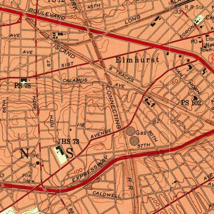
Published in 1958 from 1956 survey work, the US Geological Survey’s “Brooklyn” presents New York at a fascinating mid-century moment, when industrial waterfronts, dense residential districts, and expanding transportation networks shaped the daily life of the city. At the 1:24,000 topographic scale, the map captures not only Brooklyn itself but also adjoining parts of Manhattan, including Soho, a neighborhood later celebrated for its cast-iron architecture, artists’ lofts, and cultural reinvention. Its title is spare and authoritative, in the USGS tradition, yet the sheet is rich with urban complexity: gridded streets, rail corridors, bridges, parks, waterways, and subtle elevation contours all combine to create a portrait of metropolitan New York before many of the transformations that would define the late twentieth century.
The cartographic language of the map is both practical and elegant, reflecting the USGS commitment to clarity, precision, and scientific reliability. Urbanized areas are rendered in warm orange hues, allowing the dense fabric of streets and blocks to emerge distinctly against parks, waterways, and open spaces. Roads are differentiated in red according to classification, while conventional symbols identify railroads, public buildings, landmarked sites, and other functional features. Contour lines reveal the low but significant topographic variations of Brooklyn and lower Manhattan, reminding the viewer that even the most intensely urban landscapes are shaped by underlying terrain. The result is a disciplined, information-rich composition in which civic infrastructure and natural geography are held in careful balance.
The US Geological Survey, founded in 1879, became one of the most important cartographic institutions in the United States, producing maps that served engineers, planners, scientists, educators, and the public. By the 1950s, its topographic sheets offered a standardized and highly detailed way of understanding American landscapes, whether rural, mountainous, or intensely metropolitan. In a city such as New York, the USGS method reveals patterns often obscured by everyday familiarity: the relation of neighborhoods to waterfronts, the logic of transport corridors, and the placement of parks within a compact urban matrix. This “Brooklyn” sheet is therefore not merely a navigational document, but a governmental portrait of the city as measured, classified, and interpreted through mid-century scientific cartography.
Among the most compelling features are the great urban green spaces that punctuate the city’s density. Prospect Park appears as Brooklyn’s grand landscaped refuge, its contours and pathways set apart from the surrounding street grid, while Central Park is visible to the north as another landmark of nineteenth-century urban planning. Rivers, creeks, and harbor waters define the borough’s edges and explain the historical importance of docks, ferries, rail terminals, and industrial zones. The map also records residential neighborhoods, commercial districts, railroads, subway and transit routes, and the fine-grained mesh of avenues and cross streets. These details make the sheet a vivid record of New York as a working city, organized around movement, labor, residence, and recreation.
Seen today, “Brooklyn” is especially evocative because it predates many of the social and physical changes associated with later decades. Industrial waterfronts that once dominated parts of Brooklyn and lower Manhattan have since been transformed by redevelopment, adaptive reuse, and gentrification. Soho, shown here within the broader urban context, had not yet fully acquired its later identity as an international center of art, design, and high-end retail. Brooklyn itself would undergo profound shifts in demographics, housing, industry, and cultural reputation. The map preserves an earlier arrangement of the city, before loft conversions, waterfront parks, and post-industrial reinvention reshaped so many neighborhoods. It is a precise topographic document, but also an atmospheric historical snapshot of New York in transition.
Cities, towns and places on this map
- Soho
- Brooklyn
- Central Park
- Prospect Park
- Streets and avenues in urban areas
- Bodies of water, including rivers and creeks
- Residential neighborhoods and commercial districts
- Public transportation routes, including subways and bus lines
- Landmarked sites
- Parks and green spaces
- Industrial zones
- Railroads and crosswalks
Historical context & cartographic details
- Produced by the US Geological Survey as a historical 1:24,000 topographical map.
- Dated 1956, with a 1958 imprint.
- Published by the US Geological Survey, a scientific agency of the U.S. government.
- Shows Soho and the surrounding New York area, including Brooklyn.
- Uses topographic shading to show terrain and elevation changes.
- Urban areas are highlighted in orange hues.
- Road classifications are marked in red.
- Conventional map symbols are used to identify various features.
- Includes both urban settings and natural landscapes, such as parks and waterways.
- Provides insight into mid-20th-century urban development in Brooklyn.
- Reflects areas that have since experienced gentrification, industrial transformation, and demographic change.
Looking for a particular place? Review the detailed images to confirm that the town, landmark or feature you have in mind appears on the map. If you are unsure, ask our workshop to check before you order.
Detailed maps are especially rewarding at larger sizes, where names, boundaries and decorative features have more room to be appreciated. Use the close-up preview and size guide to choose the right scale for your wall.
This map looks amazing at sizes all the way up to 50in (125cm). If you are looking for a larger map, please get in touch.
The model in the listing images is holding the 16x20in (40x50cm) version of this map.
Where personalisation is available, you can add a short title or dedication, mark one meaningful place, or request one considered visual detail. See personalised map examples.
Every piece is printed to museum-grade archival standards using fade-resistant pigment inks on acid-free matte paper. Choose an unframed map print, framed map or canvas using the finish options above. Framed maps use crystal-clear optical acrylic and arrive ready to hang.
With its rich detail and strong sense of place, this map makes a considered gift for a new home, anniversary, retirement or anyone with a personal connection to the area shown. Still deciding? Explore our collection of rare old and vintage maps to discover another place, period or style.
Collapsible row
Collapsible row